|
| Summit View towards Coquihalla Hwy and Yak Peak |
Location: Coquihalla Hwy east of Hope
Driving Time: 2 hr 40 min from metro Vancouver
Ascent Time: 3 hours
Complete Time: 5.5 hours
Start Elevation:
1220 m
Max Elevation:
2100 m
I planned to climb Coquihalla Needle earlier in July, as "side trip" during my drive east to Glacier NP, Montana. But at least minute my friend Greg from San Diego invited me to visit in Anacortes, WA -- so I drove east along I-90 instead (with some great camping and hiking in Cascades east of Seattle). Needle had to wait. Finally when gorgeous, and possibly one of last spells of dry and sunny weather came to lower Mainland in mid-October I decided to finally knock it off the list.
Needle is not difficult or long outing. But the drive is. Getting out of Vancouver takes forever, which is followed by boring stretch against the sun for about an hour to Chilliwack (where the gas is usually 10 cents cheaper than in Vancouver!) After that the road gets more interesting, specially as you head along Coquihalla east of Hope. Two and a half hours since I left Vancouver I arrived to the Zapkios rest area -- exit was not easy to identify, to which M. Gunn book warns -- I almost missed it. Best thing is to keep an eye on two large gravel sheds to the right; Yak peak is almost directly across the road to the left.
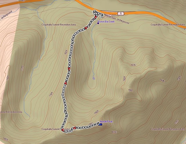
Google Earth view of the route. First part, steep climb out of the forest (about 35-40 minutes and 300 vertical) is out of picture to the right. From there the trail follows gentle shoulder towards wide, windswept pass west of the summit from where long ridge is followed to the summit.
Several other cars were parked at gravel sheds, which told me I was on the right spot; but there was no obvious trailhead. After some searching I realized that you have to backtrack for some 5 minutes (on foot) along side trail that parallels the highway. There I saw BC Parks table identifying the start of Needle Trail

Yak peak across Coquihalla Hwy from the Trailhead. It reminded me of Mt. Yamnuska in Rockies front ranges near Canmore -- normal hiking route goes around to the right, while there are many rock climbing routes on the face. It is also listed in Scrambles book, and on my target list for 2011.
Emerging to the shoulder after steep switchbacks on lower, forested slopes. The trail is well flagged (which helped me in return as I descended in the dark). From here hiking is simply awesome, first through semi-open forest and then meadows and small ponds towards the shoulder and start of scramble part.
Semi frozen pond along the shoulder; Needle in upper right. I passed group of hikers that were already descending here -- this appears to be quite popular trail.
Awesome panoramic views towards sea of peaks north further along the shoulder.
Vicana and Guanaco peaks in upper right are also very popular scrambles but not listed in Matt Gunn's book.
Frozen fissures in granite rock. It is only mid-October, but water is already frozen. Oh Canada!
Approaching the wide pass and beginning of the ridge leading to the summit of Needle peak. The bump in center is first objective; true summit is hidden at this point.
Large cairn indicating the end of hiking part. From here the trail turns sharp left and hikes up the slope between rock outcrops, then angles right for a short time -- follow the orange markers. Finally steep gully leads to the bump in previous photo and start of Needle Ridge.
Unexpected Crux of the route at top of steep gully -- the book does not mention it at all! It is vertical, about 4-5 meters high and overhanging chockstone on top makes it extremely hard. I fussed around for good 10 minutes, but had problems pulling myself up. Finally I bypassed to the right (out of the photo) which was quite exposed. I've done enough scrambles to classify this as "difficult". In contrast, official Crux further along the Ridge rated moderate was laughably easy.
Rest of the route, above the crux. Needle summit just left of center. This part was very enjoyable. The final part looks like it might have its moments, but once I had my nose against the rock the way was easy. It took me about 30 minutes from this point to the summit.


Approaching the summit block correct way becomes obvious. The route, indicated by red line scrambles diagonally right on wide ledge then circles around the corner leading to crux chimney. I scrambled to the top (center left), then traversed diagonally right on small ledges towards the notch in upper right on excellent rock with little exposure. This part was very enjoyable
Great panoramic views east from the Summit. Had it not been for cold wind and lateness of the day, I'd probably linger much longer. There was a Register hidden in summit cairn, so I signed my Gunn summit #14, then after quick snack headed back.
Summit memorial plaque to the fellow named "Danny Epp"; he was only 23 years old. There appears to be some confusion about this, and I could not find on Internet the true background story. If you have some information, please let me know!
Descending from the ridge I run into a group of Snow Ptarmigans. They were very well camouflaged -- I almost missed them.
The rest of descent was pretty uneventful. Downclimbing the crux chockstone into the steep gully was much easier than expected, and soon I was hiking down the shoulder. The sun has set down, and moon came out giving me this sublime view of the peak I just climbed an hour ago.
Final descent was in dark -- I am so glad flashlight is standard part of my equipment. Finally I was down to the parking lot around 7 pm; my car was the only one (as usual). What a wonderful hike, and I wowed to return to this area next summer to explore north side of Coquihalla Highway
Finally here are the stats from my Garmin -- not really necessary for simple outing like this, but it has became a routine.
 |
| GPS Tracks |
 |
| Vertical Elevation Profile |


 Yak peak across Coquihalla Hwy from the Trailhead. It reminded me of Mt. Yamnuska in Rockies front ranges near Canmore -- normal hiking route goes around to the right, while there are many rock climbing routes on the face. It is also listed in Scrambles book, and on my target list for 2011.


 Approaching the summit block correct way becomes obvious. The route, indicated by red line scrambles diagonally right on wide ledge then circles around the corner leading to crux chimney. I scrambled to the top (center left), then traversed diagonally right on small ledges towards the notch in upper right on excellent rock with little exposure. This part was very enjoyable